

A technical explainer covering what AIS was designed to do, how the system works, the difference between terrestrial and satellite reception, who is required to carry it, and the limitations worth understanding before relying on it.
By Wail Sabbagh, Commercial Director, BigOceanData
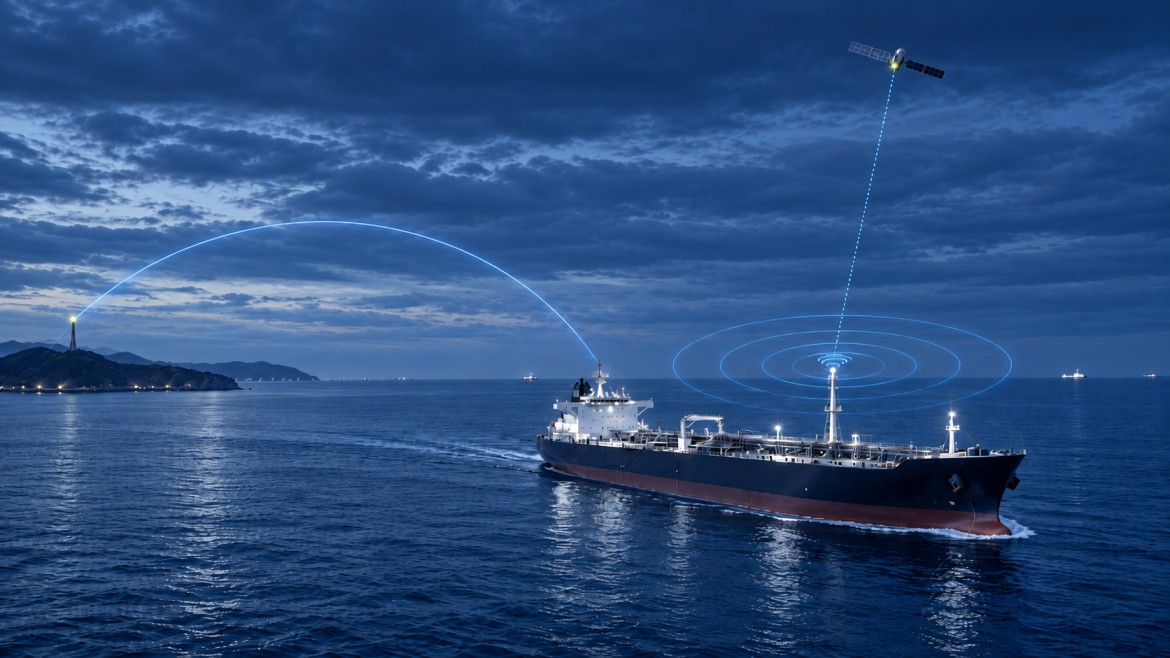
Almost every public map of ship movements is built on the same underlying system. AIS, the Automatic Identification System, is a VHF radio broadcast that ships make continuously, giving their identity, position, course and speed to anyone within range.
It is the foundation of modern vessel tracking. It is also widely misunderstood, partly because it works so well in the conditions it was designed for that people assume it works everywhere.
This is an explanation of what AIS actually is, how it works, and where its limits sit.
What AIS was designed to do
AIS was not built for tracking. It was built to stop ships hitting each other.
Radar had been the primary collision-avoidance tool at sea for decades, and it still is. But radar detects an object without identifying it. A watchkeeper could see a return on the screen and know something was there, without knowing what it was, who it belonged to, where it was bound or what it intended to do next.
AIS solved that. Each ship broadcasts its own identity and movement data on VHF, and every other AIS-equipped ship within range receives it. Instead of an anonymous radar contact, the officer of the watch sees a named vessel with a course, a speed and a rate of turn, and the system calculates the closest point of approach automatically.
The International Maritime Organization adopted the carriage requirement in 2000 as part of a revised SOLAS Chapter V. The first ships were fitted from 1 July 2002, and the phased implementation was complete by 31 December 2004.
Everything AIS is used for now, including fleet tracking, port analytics, sanctions monitoring, trade statistics and the live maps on public websites, is a secondary use of a collision-avoidance system. That origin explains most of its strengths and nearly all of its limitations.
How AIS works
The broadcast
An AIS transceiver combines a VHF radio with a position source, usually GPS, and connections to the ship’s other navigation equipment such as the gyrocompass.
It transmits on two dedicated channels in the marine VHF band:
- AIS 1 at 161.975 MHz
- AIS 2 at 162.025 MHz
These were created by splitting marine channels 87 and 88. Data is sent at 9,600 bits per second using Gaussian minimum-shift keying.
The transmission is a broadcast, not a connection. There is no pairing, no handshake and no addressing in the normal case. The ship announces itself continuously to anything listening.
What is transmitted, and how often
AIS sends two kinds of information on different schedules. The full message specification is published by the US Coast Guard Navigation Center, which maintains a public reference for all 27 message types.
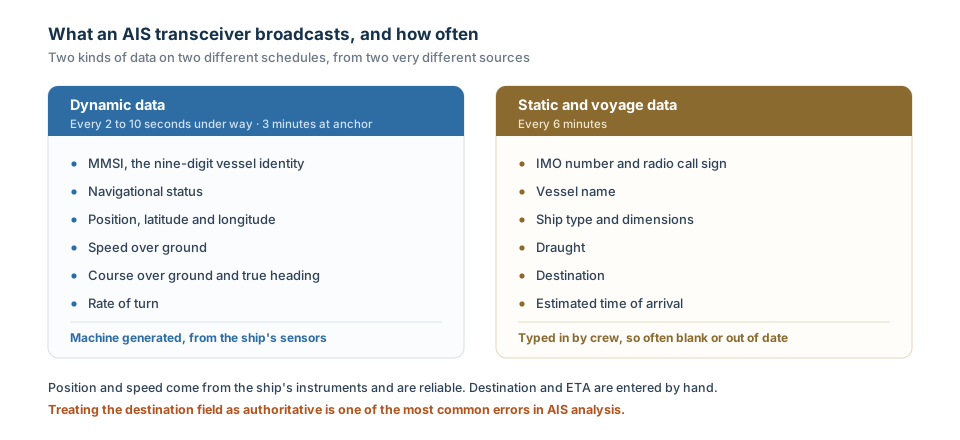
The distinction matters more than it looks. Dynamic data comes from the ship’s sensors automatically. Static and voyage data is entered by hand, which is why destination fields are so often blank, abbreviated, out of date or simply wrong.
The message types that matter
AIS does not transmit “positions”. It transmits numbered message types, 27 of them, and which type carried a position tells you a great deal about how much to trust it.
Most explainers skip this. Anyone working with an AIS feed hits it immediately.
| Type | What it carries | How often |
|---|---|---|
| 1, 2, 3 | Class A position, course, speed, heading, rate of turn | 2 to 10 seconds under way, 3 minutes at anchor |
| 4 | Base station report, including position and UTC time | Every 10 seconds |
| 5 | Class A static and voyage data: IMO number, name, ship type, dimensions, draught, destination, ETA | Every 6 minutes |
| 9 | Search and rescue aircraft position | Every 10 seconds |
| 14 | Safety-related broadcast | As required |
| 18 | Class B standard position report | 30 seconds moving, 3 minutes stationary |
| 19 | Class B extended position report, adding ship particulars | Every 6 minutes |
| 21 | Aid to navigation report, from buoys, lighthouses and virtual marks | Every 3 minutes |
| 24 | Class B static data: name, type and dimensions | Every 6 minutes |
| 27 | Long-range position report, designed for satellite reception | Every 3 minutes |
Message 27 is the one worth understanding properly, because it explains why two positions on the same map can mean very different things.
It was added to the standard specifically so satellites could receive AIS, and almost everything about it is a compromise for that purpose. It is compressed to 96 bits against 168 for a standard position report, which buys tolerance for the propagation delays involved in reaching orbit. It transmits on two dedicated channels at 156.775 and 156.825 MHz rather than the normal AIS channels, alternating between them, so each is used once every six minutes.
Three consequences follow, and all three matter if you are reading the data:
- Position resolution drops to a tenth of an arcminute, against ten-thousandths in a standard report. That is roughly a thousand times coarser, which at sea means a position good to a few hundred metres rather than a few metres.
- There is no timestamp in the message. The receiving system applies one when it arrives. So the time attached to a Message 27 position is the time of reception, not the time of transmission.
- It is transmitted only when the ship is outside base station coverage, which is deliberate. Within terrestrial range, a shore station already has the full-resolution report and the long-range message would be redundant traffic.
A dot on a tracking map carries none of this. One may be a Message 1 received by a shore station eight seconds ago and accurate to metres. Another may be a Message 27 received by a satellite, timestamped on arrival and accurate to a few hundred metres. Both look identical.
Sharing the airwaves: SOTDMA
The clever part of AIS is how hundreds of ships share two radio channels without talking over each other.
Each minute is divided into 2,250 time slots per channel, 4,500 across both. A single position report occupies one slot of 26.66 milliseconds, carrying 256 bits.
Class A transceivers use Self-Organising Time Division Multiple Access. Each unit maintains a map of which slots are in use nearby, selects a free one, and announces in advance which slot it will use next. No shore station coordinates this. The ships organise themselves.
When the system is busy, it degrades deliberately rather than failing. Slots can be shared and the system tolerates overload of several hundred percent, with distant targets dropping out first so that nearby vessels, the ones that matter for collision avoidance, stay visible.
That design decision is sensible for safety and inconvenient for tracking. The system is built to discard the distant ship, which is often precisely the one a shore-based observer wants to see.
The device classes
Not every AIS transmission is the same.
| Type | Power | Reporting rate | Typical use |
|---|---|---|---|
| Class A | 12.5 W | Every 2 to 10 seconds | Commercial vessels under SOLAS |
| Class B “CS” | 2 W | Every 30 seconds | Smaller commercial and leisure |
| Class B “SO” | 5 W | Up to every 5 seconds | Newer standard, SOTDMA-based |
| Base station | — | — | Shore installations |
| AtoN | — | — | Buoys, lighthouses, navigation marks |
| AIS-SART | — | 8 messages per minute | Search and rescue beacon |
Class A has transmission priority. Class B “CS” listens for a quiet slot before transmitting, which means in congested water it may find none and stay silent. That is the main reason small craft disappear from busy harbours while large ships remain visible.
Terrestrial and satellite AIS
This is the distinction that causes the most confusion, and it is the one that governs how reliable any AIS picture actually is.
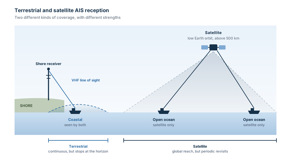
Figure 1 Terrestrial reception is continuous but stops at the horizon. Satellite reception is global but periodic.
Terrestrial AIS
AIS is VHF, so terrestrial reception is limited by line of sight. Published figures usually give a range of 20 to 40 nautical miles, but quoting a single number is misleading, because the range depends almost entirely on how high the two antennas are.
Radio waves at VHF bend slightly with the atmosphere, so the radio horizon sits a little beyond the visual one. The usable approximation is:
range in nautical miles ≈ 2.23 × ( √h₁ + √h₂ )
where h₁ and h₂ are the two antenna heights in metres. Because the relationship is a square root, height has diminishing returns, but the practical spread is wide:
| Shore antenna height | Ship antenna at 20 m | Resulting range |
|---|---|---|
| 10 m, a harbour office | 20 m | 17 nautical miles |
| 50 m, a coastal mast | 20 m | 26 nautical miles |
| 200 m, a hilltop site | 20 m | 42 nautical miles |
| 600 m, a mountain site | 20 m | 65 nautical miles |
This is why coverage maps from different providers disagree, and why the same stretch of coast can be well covered or barely covered depending on where the receiver was installed. It is also why reception occasionally extends far beyond any of these figures: tropospheric ducting, where a temperature inversion traps the signal in a layer of atmosphere, can carry VHF hundreds of miles. That is unpredictable and cannot be planned around.
Within range, terrestrial AIS is excellent. Updates arrive every few seconds, latency is near zero, and reception is reliable.
Beyond it, there is nothing. A shore receiver cannot see a ship over the horizon, no matter how good the equipment is.
Satellite AIS
AIS was not designed to be received from space, and for the first decade nobody expected it to be. But VHF propagates further vertically than horizontally, and from 2005 onwards satellites in low Earth orbit were shown to detect AIS transmissions successfully.
Satellite AIS extends coverage across open ocean, which terrestrial networks can never reach. It comes with two constraints.
Revisit interval. A satellite in low Earth orbit passes over a given point periodically rather than continuously. How often a particular vessel is seen depends on constellation size, orbital geometry and latitude. There may be minutes between reports, or considerably longer.
Message collision. A satellite sees a vastly larger area than a shore station. AIS was designed so that ships within VHF range of each other coordinate their time slots, but ships 500 nautical miles apart cannot hear each other, so they may transmit in the same slot. From the ground that is fine. From orbit, both arrive simultaneously and neither is readable.
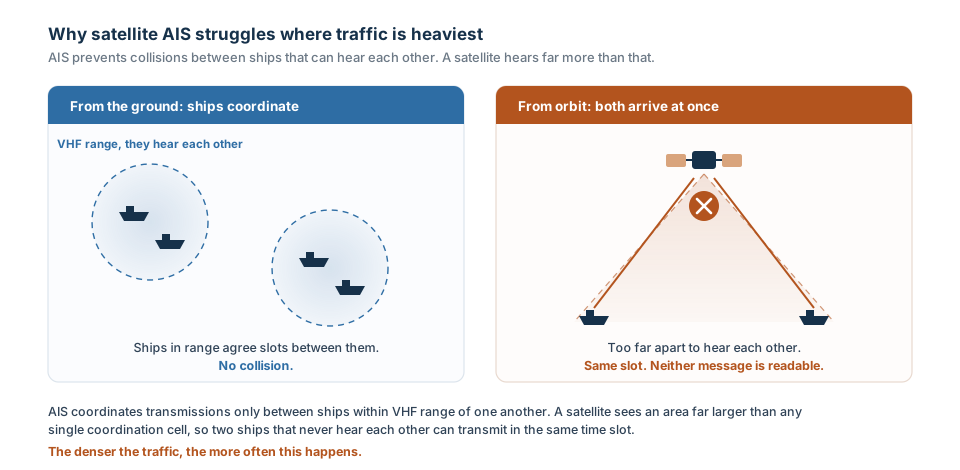
Figure 2. Why satellite AIS performs worst where traffic is heaviest.
The counterintuitive result is that satellite AIS performs worst where traffic is heaviest. In the Singapore Strait, the approaches to Chinese megaports, or the Dover Strait, satellite reception suffers precisely because there are so many ships.
The two together
Neither is sufficient alone. Terrestrial gives you high-frequency, low-latency coverage in a coastal band. Satellite gives you global reach at lower and less predictable frequency. Most commercial AIS data services combine the two.
Understanding which one produced a given position matters. A report from a terrestrial receiver three minutes ago means something different from a satellite report that may be the only one in six hours.
Who must carry AIS
Carriage is mandated by SOLAS Chapter V, Regulation 19.2.4. The full text of Regulation 19 is published by the UK Maritime and Coastguard Agency. It applies to:
- All ships of 300 gross tonnage and above engaged on international voyages
- Cargo ships of 500 gross tonnage and above not engaged on international voyages
- All passenger ships, irrespective of size
Regional rules extend this. EU inland waterway vessels have required a certified Class A unit since 2010, and EU fishing vessels over 15 metres since May 2014. The United States has its own carriage requirements covering commercial vessels of 65 feet and above and towing vessels of 26 feet and above with more than 600 horsepower.
Who is not covered. Warships, naval auxiliaries and government-operated ships are exempt. Most fishing vessels below regional thresholds are exempt. Leisure craft generally fit AIS by choice rather than requirement.
On switching off. SOLAS requires that ships fitted with AIS maintain it in operation at all times, except where international agreements, rules or standards provide for the protection of navigational information. So a transmission gap is not automatically evidence of wrongdoing. A master has discretion where broadcasting the position would compromise the safety or security of the ship, which is a recognised concern in piracy-affected waters.
What AIS is used for now
The system has been adopted far beyond its original purpose.
Collision avoidance remains the primary function, used alongside radar rather than instead of it.
Vessel traffic services use AIS to manage movements in ports and congested waterways.
Search and rescue benefits both from knowing which vessels are near a casualty and from AIS-SART beacons, added to the GMDSS framework in 2010.
Aids to navigation broadcast their own positions, and can transmit sea state and weather data from buoys. A virtual AtoN can place a mark on a chart where no physical buoy exists.
Fisheries monitoring allows authorities to track fleet activity along a coastline.
Accident investigation uses historical AIS as evidence. It provides more accurate time, position, heading and rate-of-turn data than radar, and unlike voyage data recorders, which IMO requires to retain only 12 hours, AIS history is held indefinitely by data providers.
Infrastructure protection lets owners of cables and pipelines monitor vessels near their assets.
Fleet and cargo tracking is the commercial use most people encounter.
Statistics and economics is the newest. The UN Statistics Division has built AIS-derived indicators into the UN Global Platform, covering port traffic, trade flows, fishing activity and shipping emissions estimates.
The limitations
Every limitation below follows from AIS being a cooperative, unauthenticated broadcast designed for short-range collision avoidance.
It has no security. There is no authentication, no encryption and no verification. AIS relies entirely on participants transmitting honestly. A 2021 analysis concluded that adding digital signatures is not currently practical, because a signature would be longer than the message it signs and would consume much of the available bandwidth.
It can be spoofed. False AIS data can be injected into the data streams used by tracking websites, or transmitted over the air with a software-defined radio. Researchers have documented large numbers of fabricated tracks, including naval vessels appearing in waters they were nowhere near. Commercially, vessels have been observed falsifying position to conceal sanctioned trade.
Static data is manually entered. Destination, ETA and draught are typed in by crew. They are frequently wrong, stale or blank. Treating the destination field as reliable is a common analytical error.
Coverage is not uniform. Terrestrial reception stops at the horizon. Satellite reception depends on revisit intervals and degrades in dense traffic. Neither provides the continuous global picture that public tracking maps imply.
Equipment fails. Transceivers lose power, are configured incorrectly, suffer antenna faults, or are switched off during port stays. A silent vessel is not necessarily hiding.
It can be jammed. GPS and VHF interference affects AIS along with everything else. In October 2022 a jamming incident near Denmark’s Great Belt Bridge interrupted transmissions from nine vessels over a 50 by 30 kilometre area for about ten minutes.
Congestion degrades it. The design sacrifices distant targets to protect nearby ones. That is correct for safety and unhelpful for wide-area monitoring.
What comes next
AIS is over twenty years old as a mandated system, and the congestion problem has become acute enough to require a successor.
VDES, the VHF Data Exchange System, is the main development. Defined in ITU-R M.2092, it adds frequencies and uses them more efficiently, offering roughly thirty-two times the bandwidth of AIS, along with a satellite component designed from the outset rather than discovered by accident. It is intended to carry e-navigation services and secure communications that AIS cannot support.
R-Mode is a related initiative using maritime radio signals as a backup positioning source independent of GNSS, addressing the risk that jamming or spoofing of satellite navigation disables AIS along with everything else.
Authentication remains unresolved. Proposed approaches include digital signatures, timed-release key schemes and signal-analysis techniques that flag implausible reports, but bandwidth constraints mean none is deployable within AIS as it stands. VDES may provide the room.
Adoption will be slow. AIS is fitted to well over a million vessels and the transition will take many years. For the foreseeable future, AIS remains the backbone of maritime situational awareness, with all the properties described above.
In summary
AIS is a cooperative VHF broadcast designed to stop ships colliding, which the world subsequently repurposed as a global tracking system. It does the first job very well. It does the second job well enough to be genuinely valuable, provided you understand what you are looking at.
The useful mental model: AIS tells you what a ship is saying about itself, received by whatever equipment happened to be in range at the time. That is a different thing from knowing where a ship is, and the gap between the two is where most analytical errors live.
If you are choosing between AIS providers, we have written a comparison of MarineTraffic, VesselFinder and BigOceanData. Our Plans start at $189 a month with satellite and terrestrial AIS included on every tier. See our AIS Vessel tracking page for more information.
Sources and further reading
- IMO, AIS transponders and carriage regulations
- US Coast Guard Navigation Center, AIS messages, reference for all 27 message types
- ITU-R M.2092, technical characteristics for VDES
- IMO Resolution A.917(22), guidelines for the onboard operational use of shipborne AIS
- ITU-R M.1371, technical characteristics for AIS
- IALA Guideline G1117, VDES overview
- UN Statistics Division, AIS Handbook, for statistical applications