

How AIS Continuity maintains vessel visibility through multiple position sources
AIS is the foundation of modern vessel tracking. For most ships, in most waters, it provides the visibility that operators, managers and security teams need.
But AIS was not designed to provide uninterrupted global tracking in every operating condition. Terrestrial reception is limited by the range of VHF transmissions. Satellite AIS extends coverage much further, but reporting intervals depend on satellite availability and network conditions. In congested waters, messages can be lost when many transponders share the same channels. Equipment can fail, be switched off, or transmit an inaccurate position.
When that happens, the vessel disappears from an AIS-only operational picture.
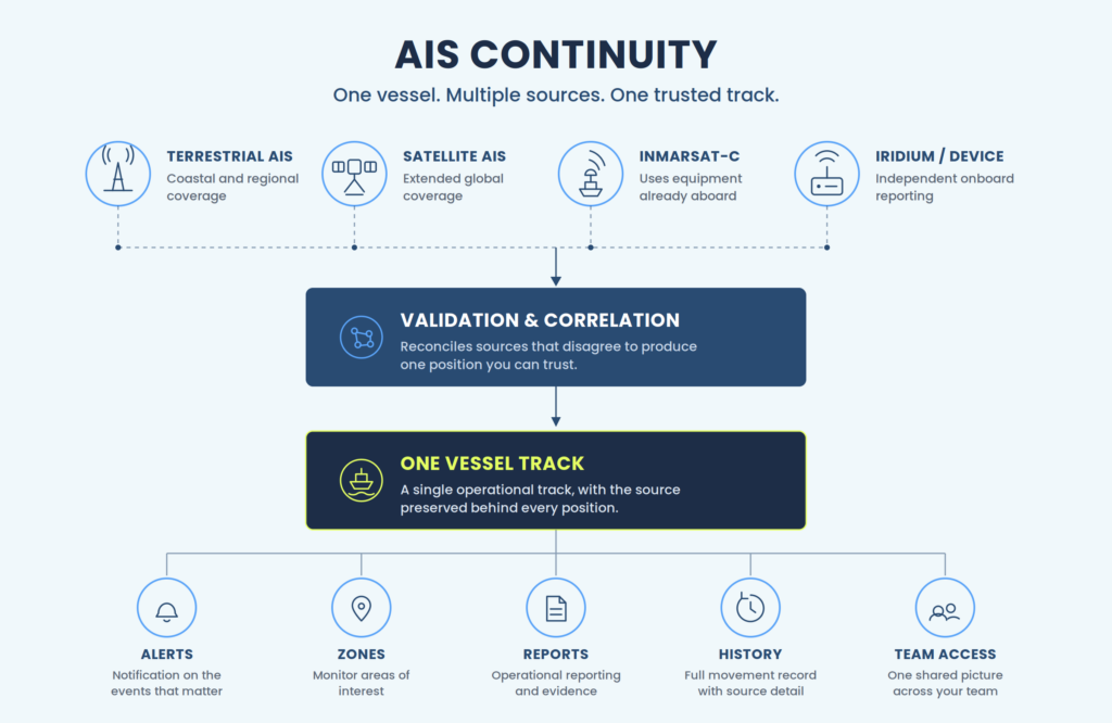
AIS Continuity is how BigOceanData keeps it visible. Authorised operators can supplement AIS with independently reported positions from sources such as Inmarsat-C, Iridium and onboard tracking devices. Those reports are validated, correlated and displayed within the same vessel track, alerts, zones and reports the operations team already uses.
AIS Continuity is for organisations that own, operate, manage or have authority over the vessels they monitor. It does not replace AIS. It provides an additional reporting path for vessels where continuity of visibility matters.
Built for multiple sources, not adapted to them
The BigOceanData tracking engine was designed from the outset to accept position reports from sources other than AIS.
Inmarsat-C, Iridium and onboard device positions are not a separate product, and they are not displayed in a second monitoring system. They enter the same processing pipeline as terrestrial and satellite AIS, and appear in the same operational environment.
For the user, that means supplementary positions support the same:
- vessel track
- alert
- geographic zones
- movement history
- scheduled reports
- incident review
There is no second map to watch and no separate workflow to learn. A vessel with supplementary reporting behaves exactly like any other vessel on the platform. It simply stops disappearing.
Why do vessels disappear from AIS
AIS remains the primary source of vessel position information, and the only source that gives a broad picture of surrounding AIS-equipped traffic. Its limitations arise from how the system was designed.
AIS is broadcast over VHF, so terrestrial reception is limited by range, and coverage reduces once a vessel moves beyond the receiving network. Satellite AIS extends visibility across open water, though reporting frequency depends on satellite coverage, revisit intervals and message congestion. In busy waters, individual messages can be delayed or lost when large numbers of vessels transmit over the same channels. Equipment can fail, lose power, be configured incorrectly, or be switched off while a vessel is alongside. And in some situations, the broadcast continues even though the position inside it is inaccurate, so a vessel appears to be reporting normally while the reported location is unreliable.
None of these limitations reduces the importance of AIS. They do mean that certain vessels, routes and operating conditions justify a second position source.
The position sources used for AIS Continuity
Different fleets need different reporting arrangements. AIS Continuity supports several supplementary sources, depending on the vessel, the equipment already aboard and the reporting frequency required.
| Source | Typical use | Equipment requirement | Main advantage |
| Inmarsat-C | Commercial vessels with compatible terminals already aboard | Often configuration rather than new installation | Makes use of existing satellite equipment |
| Iridium | Global operations, including higher latitudes | Usually a dedicated unit | Global coverage and configurable reporting |
| Onboard tracking devices | Fisheries, security and specialist monitoring | Dedicated equipment | Independent, scheduled reporting |
| SSAS | Ship security alerting under the ISPS framework | Uses the vessel’s approved SSAS arrangement | Integrates security reporting with the same platform |
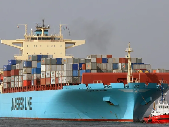
Inmarsat-C is often the most accessible route, because many SOLAS-class vessels already carry compatible equipment. Whether reporting can be enabled through configuration depends on the terminal, its service status and the authorisations required, but where the existing equipment is suitable, this is the fastest way to add a second source. SSAS reporting operates through the same infrastructure: Maersk has maintained its integrated SSAS service with BigOceanData across successive contract terms.
Where Starlink and VSAT fit
Starlink and VSAT are communications services rather than independent sources of vessel position. They can carry position information derived from the vessel’s navigation systems or from a dedicated tracking device, but they do not originate a position of their own, so the resilience of the resulting report depends on the source the location came from and on the vessel’s wider onboard systems remaining available.
Validation and correlation: turning multiple reports into one track
Collecting several position feeds is the straightforward part. Reconciling them is not.
Different sources report at different intervals, with different accuracy, through different networks, in different sequences and with varying delays. They also disagree. An Inmarsat-C position and the most recent AIS report can place the same vessel in two different locations, and one of them is wrong.
Plotting both on a map and leaving the operator to decide which is reliable is not a product. It is a pile of data with the difficult part still in it.
AIS Continuity validates and correlates the available reports into a single operational vessel track. The platform determines which position to use while preserving the source behind every report, so the operations team can see:
- the vessel’s correlated position;
- the source of individual reports;
- changes between reporting sources;
- the timing and duration of AIS interruptions;
- the evidence behind a historical movement record.
If a decision or an incident is questioned later, the underlying reporting history is there.
This validation and correlation capability has been refined through years of operational use across government, security and commercial fleets, and it is the element that is difficult to replicate.
Proven in operational service
The multi-source capability behind AIS Continuity is in continuous operational service, in environments where AIS-only tracking has never been sufficient.
A leading European shipping company operating 36 bulk carriers worldwide uses scheduled Inmarsat-C reporting alongside AIS to support tracking in regions where AIS coverage is limited. The company renewed its relationship with BigOceanData following its initial contract term.
A US-based superyacht management company combines AIS, Inmarsat-C and Iridium reporting to support global vessel visibility, and has renewed its BigOceanData subscription.
A European Fisheries Department is now in its twelfth year of using BigOceanData Fisheries Vessel Monitoring System technology and support.
Different fleets, different requirements, the same underlying need: position information that remains usable when AIS alone cannot provide the complete picture.
What AIS Continuity does not do
Clear limitations matter when evaluating any tracking capability.
It does not replace AIS: AIS remains essential and is sufficient for most vessels in most operating conditions. AIS Continuity serves a narrower purpose: an additional reporting source for selected vessels, where an interruption in AIS coverage would create an operational problem.
It does not track unrelated vessels through onboard sources: Enabling an existing terminal or fitting a dedicated unit requires the approval and cooperation of the owner, operator, manager. For an organisation monitoring third-party vessels with which it has no operational relationship, supplementary onboard reporting is not available. No tracking provider can obtain an independent onboard position source without access to, or cooperation from, the vessel.
It does not guarantee uninterrupted reporting: An additional source improves resilience, but any equipment or communications service can be affected by technical, operational or environmental issues.
The purpose of AIS Continuity is to reduce dependence on a single reporting source and create a more resilient operational picture. It is not a claim that a vessel will never experience another reporting interruption.
Getting supplementary reporting aboard
The question that delays most continuity projects is not whether supplementary reporting would be useful. It is who will arrange it. Vessels are often trading internationally when the decision is made, and equipment, technicians, authorisations and port calls all have to be coordinated without disrupting the schedule.
BigOceanData supports three deployment routes, and most fleets need only the first.
1. Configure equipment already fitted
Where a vessel carries a suitable Inmarsat-C terminal, scheduled reporting can be enabled without purchasing or installing new hardware. BigOceanData works with the customer and the relevant vessel contacts to confirm compatibility, configure the reporting arrangement and verify that positions are being received correctly.
2. Supply dedicated equipment
Where no suitable terminal is available, BigOceanData sources an appropriate tracking unit, specified according to the vessel, the operating region, the reporting interval required and the degree of reporting independence needed.
3. Manage the full deployment
Where the customer would rather not coordinate the project internally, BigOceanData manages it: equipment specification, supply, delivery to an agreed port, coordination with the customer’s technical team or vessel agent, installation planning, commissioning, activation, and verification that reports are being received.
For larger fleet programmes, deployment is planned around existing trading patterns, so units are fitted at port calls that were happening anyway.
Start with the vessels that matter most
AIS Continuity is configured vessel by vessel. A fleet does not need to enable supplementary reporting on every ship.
Most customers begin with a smaller group, typically vessels that:
- undertake long ocean passages
- operate in regions with inconsistent AIS coverage
- trade in security-sensitive areas
- have already experienced significant AIS gaps
Where suitable equipment is already fitted and the necessary approvals are in place, reporting can be enabled without a physical installation. That makes it practical to start with the highest-priority vessels, assess the operational benefit, and extend the service from there.
Request an AIS Continuity assessment
Send us the vessels that matter most and the routes on which they operate here.
We will help you identify which vessels already have strong AIS coverage, which routes create greater visibility risk, which vessels may already have suitable equipment aboard, where a dedicated reporting unit would be appropriate, and the most practical deployment route for each one.
Losing sight of a vessel shouldn’t mean losing situational awareness.
About BigOceanData
BigOceanData is a UK-based vessel tracking and maritime intelligence platform, processing 80 million AIS position reports a day across more than 450,000 vessels and 4,500 monitored ports. The platform provides satellite and terrestrial AIS tracking, zone monitoring and alerting, route optimisation and multi-year track history to fleet operators, insurers, security firms and government bodies. Clients include Maersk, Crisis24 and Cory Brothers.
Media enquiries:
Wail Sabbagh, Commercial Director, +44 (0)7782 325414, wail.sabbagh@bigoceandata.com